The following transcript has been edited for length and readability. Listen to the entire discussion here on The Broadband Bunch.
Pete:
Hello, and welcome to another episode of The Broadband Bunch. In today’s episode, we speak with Will Mitchell. He is the CEO and co-founder of VETRO FiberMap. Will explains geospatial or map-based analytics. He helps us understand why the telecommunication is now moving towards map-based information. He helps us understand how network operators can benefit from intelligent maps. We talk a little bit about post-COVID and how better understanding of our infrastructure can accelerate the systems that we desperately need during this time. We take a look at what map-based insight in analytics may look like in the future. I hope you enjoy the episode.

Pete:
A lot of the conversations that we have had have been really interesting to talk about plans and expectations prior to pandemic and then how that’s impacting us, especially in our industry. It’s really bringing it into the limelight. And the capabilities and the partnerships that you have really show the potential of how we all can get smarter using data and smarter to understand the systems and networks that all the citizens and global communities are counting on us to improve and grow and develop.
Pete:
Before we get into that, as I mentioned you’re a co-founder, and it would be interesting to understand your personal journey. How did you decide to start a software company in this space? Where did you come from? What got you on that path?
Will:
I do feel like we’re in this big connectivity moment. With everyone distributed and working from home, it’s just never been more prominent – the need to be online and connected in a quality manner. These networks that we’re talking about are fundamentally important to everyone now.
Launching a GIS Career
Will:
Just a little bit about my background and how I got here, it goes back a couple decades. I grew up in Maine. I’m speaking to you here from Portland, Maine where our company is based. I went away to study at Georgetown. I went to the School of Foreign Service and got a degree in international relations, which interestingly led into a geography interest and a geography program of study in grad school.
Will:
That geography program led squarely into mapping technology known as GIS, Geographic Information Systems. That launched a GIS career. I went through a couple of different flavors of applying GIS – starting in forestry and natural resources briefly, then over into engineering and supporting an engineering firm and did lots of projects with maps and map database creation.
Will:
I then came home to Maine, to Portland, to start a GIS consultancy. In that role, I got a lot of exposure, for about a decade, helping people utilize desktop GIS. This would’ve been around the year 2000 timeframe, getting started on that. Then as things progressed forward, going mobile, going cloud, my own career kind of followed that path. In 2008, I got together with my co-founder, Sean Myers, and founded a mapping software development shop. The name of it was NBT Solutions. Sean, by way of introduction, is from upstate New York, Rochester area. He was working in engineering GIS, and we crossed paths and got together probably 15 years ago on some municipal GIS projects in the utilities space. So, we started with water and sewer system inventory and mapping which, as you can imagine, led neatly into network mapping. That network mapping is applied in our fiberoptic network context now.
Will:
Sean’s got that utility GIS background. I should also mention a third partner. At the outset we had a technology expert named Scott Stewart down in Williamsburg, Virginia. He left the company prior to our conversion over to the VETRO focus, but he was a great friend and a brilliant technologist. He fundamentally helped shape the team and our approach to building software. That’s a little bit of the origin story. I didn’t even get to VETRO yet. Should I keep going?
Pete:
Before we get into VETRO, a couple of questions. GIS, to me, it’s always been a subset of big data or analytics when people talk about the bigger set of turning your information into insight. While GIS has been around maybe the past 15 to 20 years, it feels like it’s late to the game in the telecommunications space. Is that a good assumption? And if it is, why do you think that it’s taken this industry this long to figure it out and why now? Why do you think GIS is starting to emerge in this space?
GIS Mapping Tools & Data Analytics for Fiber Networks
Will:
It’s something that Sean and I were asking ourselves when we stumbled into the opportunity that became VETRO. In municipal asset management and utilities, GIS seems to be quite ubiquitous and mature. We were building software applications, mapping tools and GIS solutions for clients in the early years starting in 2008. VETRO came along really around 2015 and got going for real in 2016. Along the way, we found that GIS seems generally under-represented and under-utilized at least in the small and mid-sized telecom segment, the folks that we were talking to, the smaller ISPs essentially around the country.
Will:
It’s not that the big guys are necessarily happy with their mapping systems either, but we are focused on the small and midsized companies. There was a time in the 90s when I used this GIS software called MapInfo. I was trained up on ESRI, on ArcInfo and ArcView and the ArcGIS suite. That’s quite ubiquitous. MapInfo was actually very strong in telecom at the time, in the late 90s, especially in wireless.
Will:
Something happened along the way – over the next decade – after a bit of a crash, contraction and consolidation. The smaller ISPs who I would’ve thought would be using desktop GIS whether MapInfo, or ARC or something else, they tended to be gravitating mostly over to Google Earth, which isn’t really a GIS. It’s a mapping tool. It’s a good one, but there’s no database behind it. It’s not a GIS per se.
Will:
Maybe it’s just because that was free and easy and “good enough,” that it was serving as kind of the no-system system solution for many smaller operators. That’s one theory. The other theory we had sort of validated through a lot of conversation was that the tools that we’re offered in this space, the GIS and mapping tools were really enterprise in nature and geared towards larger players. No one had really tried to solve the problems for the small and mid-sized network operators in a way that really fit.
Will:
That’s really what became the opportunity we found for VETRO.
Pete:
Big data and analytics generally are overwhelming, but as you pointed out, people do try to solve these problems. They identify that certain information at the right time is helpful. There’s need for people looking for information or different ways of looking at information or suspecting that there’s insight in combining all this information. Maybe you could talk a little bit about how you take the enormous amount of data that you see in the marketplace and that you also provide and help people simplify it. How do you help them make it less of about the organization of the data and more about the extracting insight from the data?
Will:
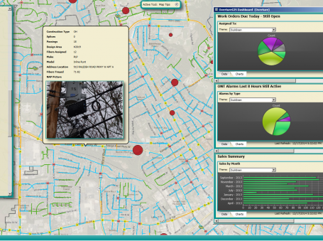
Let me try and address that at a couple of levels. VETRO FiberMap is a fiber management platform, and it’s meant for the creation and curation of an asset database for a particular network and not the outside plant elements that comprise a fiberoptic network. It’s an engineering tool at its heart including recording the connectivity and splicing and such. I say that because, something it’s not is, it’s not a discovery tool. We’re not publishing a vast database of all the fiber in the world or in the country. Rather, we are providing the tools in the container for an individual network in order to manage their own network.
Will:
We’ve seen both ends of that along the way. Prior to building VETRO, we were contracted to build a tool called fiber locator, which was more of a discovery tool. It had a lot less detail in that it was essentially marketing-level routes for example, who’s got fiber in this city or near this address? It was built in a brokerage context and a discovery context. VETRO FiberMap on the other hand goes deeper. It goes inside that cable and inventories the fiber strands and the splicing and the routes.
Will:
Going back to your question about bringing that data out and turning it into insight, that’s when we start thinking about the operation of an ISP and the service delivery over the top of the network. When you’re planning or designing, building and then ultimately managing and operating the network, you really need access to the physical and operational status of every strand of glass that’s out there at every point along the way, on a path over which data is traveling so that the operational uses of the map and the mapping information are numerous and they’re varied internal to that ISP or that network operator.
Pete:
What was missing from the current approaches? You mentioned a couple other tools that are out there, some other processes and other homegrown approaches all trying to figure it out. What do you think is kind of the secret sauce that’s going to help bring this to mainstream use and adoption?
Will:
The things that we found to be missing, and this was a process of discovery. We’re map guys, and we’re software developers with mapping backgrounds as opposed to telecom engineers. We took our cue from folks at the ISPs that need to manage and build networks. What seemed to be missing was either the tools in use didn’t go deep enough, they weren’t rich enough, so FiberLocator or Google Earth for that matter, they were scratching the surface but not solving the problem of asset management and complete end-to-end inventory. Or they were just too big and too expensive and too complicated. The small ISP serving 10,000 customers isn’t going to drop millions of dollars on a system that’s designed for a Tier One telecom.
Simplified Fiber Broadband Management with Robust Connectivity Model
Will:
That complexity is really the challenge that we tried to meet head on when we were building VETRO, take the complexity out of it. I guess fundamentally the goal there is to let the telecom engineer do telecom engineering and not have to have a master’s degree in GIS, which is what I went and got.
Will:
It’s not that fun. You want to deliver a Google Maps level experience but also the robustness and the richness of a connectivity model. All that splicing information, these records are vast and detailed, and they might live in a spreadsheet right now. You want them in a database that you can manage so that you can maintain the data over time and then get answers when you need them. That’s what it boils down to. How do I put this person back online? If there’s a problem on this cable, who’s impacted? That kind of thing.
Pete:
Adoption of a lot of solutions or software in this marketplace is really dependent on how easy is it to teach a customer how to use my tool to help them do their job? The prevailing trend has become less controlling of the process and more fitting into their process and enhancing it. Usability and understanding the processes, and as you mentioned, building solutions that are defined and designed by your clients is invaluable. That’s really how you get inside, and if you don’t bring that experience to the table but understanding how people are trying to solve problems and when they need to pick up a pencil and how you can help them.
Will:
I think about apps on the smartphone and how that just changed the whole paradigm of software. Things are super targeted, single purpose. You’ve got to be able to accomplish your mission with a single click. We try to take that philosophy into our work. It’s not easy. Fiberoptic network is pretty complicate with splitters and flow and connections and equipment and so forth. Simplifying that as much as possible from a user experience perspective really democratizes who can contribute to the map or benefit from it just by making it accessible.
Pete:
If you take out those hurdles of having to learn how to use specific tools, then more and more people can participate in that analysis or benefit from that data. Incidentally, you’re knocking down functional silos within operators or within organizations, and the same is true on the client’s side. The ISPs are trying to provide a seamless experience for their customers. But on the backend the complexity is still there.
Pete:
Are there standards out there? For example, TM Forum is helping us try to define standard definitions. Are there any GIS working groups with telecom focus that are trying to help provide that kind of standardization and interoperability that’s required for better insight but also improved usability?
Will:
There are. I want to mention a little bit about our version of building GIS tools because it’s relevant here, I think. That is to say we build in and on top of open source tools and libraries as opposed to one of the major publishers that might be offering a GIS engine or database engine. The difference being, we’re kind of constructing software from the ground up on a blank canvas, and that helped us with that design simplicity on the front end but also the whole stack is put together in a very intentional way to solve the problems that are at hand for these network managers.
Will:
The flip side of that is taking a large existing GIS-type tool and then trying to strip it down and orient it to fiber management. That’s not uncommon for a lot of industries that would be tailoring an existing GIS tool to meet the needs of that industry. So, you’re stripping down instead of building up. I would say by building up we found that we got to build the schema and the data management structures from scratch, but we did look at what was out there as best we could as far as standards for telecom data and specifically the mapping GIS data.
Will:
We did that after the fact, but it turned out we mirrored things that were going on and other tools. There was no published standard. The fundamentals of how you manage the relationships of the network and the graph model and things like that ended up matching what other systems might be using. Some of the GIS publishers are just now beginning to publish some telecom schema standards and such.
Will:
On the TM Forum side we’re a member there as well. That’s a good place to drive standards when it comes to interoperability and APIs. The other thing that we try to do is publish our capabilities through APIs because being the asset management tool and the outside point of inventory tool is just a piece of the puzzle.
Will:
The operational support systems and billing systems and CRMs and things that go into the full package of delivery and service, they need to ask questions of the map, and we want to enable that. TM Forums’ standards for APIs are a place that we are orienting ourselves as well.
Pete:
It’s good to hear about open source and standards being adopted by more and more software vendors. It’s the way of the future, and everybody benefits from it specifically our clients and the end clients. What’s the natural next step? Where does this go from here? Clearly there’s a big focus on our industry as we mentioned from the outset. If you step back and dream about not just VETRO but this capability within your client’s hands, how do you see evolving?
Shared Fiber Infrastructure Better Enabled with Accurate Data
Will:
What we’re giving people the ability to do is to memorialize, inventory and document these fiber networks that are either out there, or being built and deployed, or upgraded or expanded now. That provides a foundation, an information foundation and an asset that can be leveraged by the operator themselves or it can also be published and shared. I think that’s going to lead to more shared asset use. When you think about an open access fiber network, for example, where you might have multiple operators sharing lanes on the highway or sharing strands of fiber in a cable, or the same model applies to wireless. You’ve got different companies with antennas on a shared tower. That shared infrastructure model can be better enabled by having accurate and accessible data about those assets.
Will:
We’re going to see more of that, more leasing, more sharing, more shared use, and this information foundation can and should support that especially with more and more players getting into the game. We have customers in the municipal sector, in the electric co-op sector and a lot of others around the edges that we maybe wouldn’t have thought about as potential customers are coming in too. They’re building rings or they’re deploying fiber to the home in different contexts. Getting them to a place where they can manage and curate their own data, operate their network more efficiently, respond to trouble and outages and maintenance and break-fix more effectively and quickly, all of that is around the bend as least is what we’re hearing from our users.
Pete:
Even in this industry there’s a lot of consolidation and acquisition going on in that we have a couple of conversations coming up around and about that host merger integration, the pain part of it is discovery of current assets, location of your fiber. But also as a consequence of this pandemic where there’s going to be a new flux of money. People aren’t asking about, “Do I need effective or reliable broadband at home?” It’s like, “How can I get it faster?”
Pete:
Solutions like having all that data available and shared gets us to a better answer in the future. Also, the concern that I have is this kind of attraction now, this rush, and I think a lot of people have the sustainability of the systems that we’re going to be building. Instead of just knee jerk reaction in trying to get broadband out to underserved areas that’s really building networks that are of today instead of the future, we’re going to have to upgrade those anyway.
Pete:
Open access and shared resources and sustainable models have to be on the table. Having standards of informational sharing where we can make those types of decisions easier and less expensive to get people on board is critical to having that informational foundation as you described.
Will:
You raised a good point there about doing it right even if we are in a hurry. We’ve got some customers who are deploying fiber to the home networks, but they’re basically taking fiber out to a multi-port with four ports on it, using three of the ports for a fiber drop to nearby houses and using the fourth port for an LTE antenna for wireless coverage to quickly get to more houses that are nearby but not right on that pole.
Will:
Their plan though is to then go out and continue deploying the fiber until they reach all the homes. It’s kind of this leap frog get something in place with a wireless solution in a hybrid context and then continue doing the job of deploying the fiber for an ultimately more sustainable, more reliable, more robust network. It’s an interesting strategy.
Pete:
We’ve mentioned the pandemic a couple of times. What are the conversations you’re having with your customers right now? How do you see your organization’s role in helping them deal not only in the short term but in the medium term?
Fiber Broadband Connectivity Demand Driven by Pandemic
Will:
There’s two sides to that coin. Because our customer base tends to be in a small and mid-sized kind of sector segment of network operators and ISPs, a lot of them are small and resource constrained. Some of their customers are now feeling the pain of this economic downturn and maybe can’t pay their bills. There’s going to be some impacts, of course, with huge unemployment looming and a lot of uncertainty about which businesses will reopen and even survive in many cases.
Will:
I think on the demand side there’s a lot of uncertainty out there, economic distress. On the positive side though, what these operators are delivering is so critical, and it’s just been highlighted as such. It’s fundamentally necessary to have connectivity or we can’t do school, for example, or we can’t take care of people with telemedicine applications or we can’t do entertainment or any of these commerce things, anything really, in a distributed online marketplace or world without the network connectivity.
Will:
The medium term or midterm horizon here is just going to be massive demand. They’re telling us that they’re getting calls for upgrades and please bring fiber to my neighborhood, an incredible surge in interest and demand, which is fairly obvious why that is. They’re having trouble in some cases they’re telling us with installations, managing health and safety concerns for the installers and for the people in homes who are ordering the service. Some ISPs have a moratorium on in-home installations. There’s some different techniques being deployed there like self-service install kits and things.
Will:
It’s challenging. That’s another thing that we’ve been hearing a lot of. I think they’re also responding in admirable community service ways. We have numerous customers who are telling us that they’re putting out free public Wi-Fi hotspots in target areas and strategic areas in particular to help kids do their homework and get online without having to go travel far or go somewhere that’s not safe or convenient.
Will:
They’re doing what they can, the folks that we’re talking to, our customers, to step up and try to continue operations as best they can, continue building and expanding the networks, upgrading capacity and service in ways that can be done short term while planning for a longer term surge in growth of deployment.
Fiber Broadband Connectivity Mapping & Reporting Issues
Pete:
What about the government side of this story? You mentioned earlier about sewers and other kinds of critical infrastructure mapping – do the states and local governments, even the FCC have maps on reported broadband connectivity? Is there any value at a grander level to mapping out this type of infrastructure? and is there anybody moving in that direction?
Will:
At the aggregation level that you hear all about with the FCC and their form 477 reporting that you’re dealing with census geographies and census blocks and census block groups are convenient units to aggregate data into for things like the census. You know how many homes are here and what’s the average income and things like this. They are less appropriate and useful when it comes to telecom infrastructure and networks where you really care about points and lines and not polygons. You want to know is there a fiber cable running down this street? And can this particular home or address or business, this location, can it be served?
Will:
The reporting is a mess the way it’s done now. It over reports coverage dramatically. I think that’s widely known and agreed. The same is true for the wireless side, just sticking with wire line I don’t want to state the percentage of over statement, but there’s a problem of one location served equals all locations served at the census block level in the reporting. Blocks can be pretty big. You might have a house on a street that has good service on one edge of it, and, therefore, the whole block counts as served. You might have 50 houses on the other side of the block that don’t have any coverage at all, but they’re unfortunately counted as served.
Will:
The other thing that’s challenging about that is the fact that the actual coverage reported in terms of speed and quality is advertised speed and maximum available essentially. It doesn’t mean that every location in that reportedly served area can get that level of service or that speed. In fact, it’s often not the case. Is there room for doing it better? Absolutely. We are working with a partner called CostQuest Associates on a lot of things. They do some data work and modeling to try and estimate the build cost. Some of their work flows up to the FCC. Some of it is done for private carriers. They’ve been working on something called the broadband location fabric, which is meant to be a big giant national map of dots, points, addresses, geared towards overlaying who’s actually served and can be served at a point level, at an address level, a location level.
Will:
That’s a work in progress. They have the location data pinned down pretty well. The coverage data that would then associate to that is another matter, and that’s been done on a certain state by state level but not on the national level. There’s some other strategies and plans being explored upstream at the reporting entity level, the FCC and/or the states in terms of trying to improve broadband coverage mapping. That’s a whole ball of wax that we try to steer clear of because it’s not in our wheelhouse.
Pete:
It’s interesting to hear that there are folks that are trying to figure out where all these lines are.RD
Economic Benefits of RDOF for Fiber Broadband
Will:
To that end, there’s a huge federal fund coming online, the RDOF, Rural Digital Opportunity Fund. Many of our customers and many, many others who are calling in looking for help, are evaluating whether to bid in that auction, which will be this fall. It’s a 16 billion dollar slug of money. The rules are geared in such a way that it is likely to favor fiber or higher speeds, gigabit speeds have a heavier weight than in different auctions of the past. Hopefully, we don’t let that money flow to satellite providers to just do what they were going to do anyway, which has happened in the past.
Will:
But that’s important federal money. When you start hearing about infrastructure spend, infrastructure investment is kind of a classic way to get through a recession and get back on track in many ways. I think telecom and network infrastructure is a perfect outlet and target for that kind of investment. I think you’ll see more than just RDOF coming online to support connecting all the either unconnected or underserved type locations in the country.
Pete:
We’ve been talking with Will Mitchell, the co-founder of VETRO FiberMap. Will’s given us a great overview of this capability that’s out there, and I think there’s a big bright spotlight on this space and critical is definitely now part of the broadband vernacular I think unfortunately thanks to this pandemic. I think what you all are leading to this informational foundation is really the first critical step in how we move forward.
Learn More
Pete:
How can our listeners learn more about VETRO fiber and the work that you guys are doing?
Will:
They can check out the website vetrofibermap.com. That’s sort of the first and best place to look to get in touch with us. We have a couple of webinars upcoming through the Fiber Broadband Association. We also host a full product demo twice a month, twice monthly, and all that stuff can be found on our website. My direct contact information is simply will@vetrofibermap.com or the actual number is on the website too. We really like to engage with the community and with our customers. We welcome your inquiries and are happy to help any time.
Join us on The Broadband Bunch Facebook page to see the latest episodes, news and photos. The Broadband Bunch is sponsored by ETI Software.
© 2020 Enhanced Telecommunications.