The Short Answer: ArcGIS data interoperability gives telecom & broadband operators a way to bring spatial data from multiple sources into a single, accurate GIS environment. Esri’s ArcGIS is the leading GIS platform, & its data interoperability extension handles the translation between formats so your team can work with reliable geospatial data.
For operators, GIS accuracy isn’t just a mapping exercise. It drives network planning, asset management, service area reporting, and construction coordination. When your spatial data comes from different sources in different formats, with different coordinate systems, errors can creep in fast. A misaligned fiber route or an outdated asset record can mean wasted truck rolls, inaccurate broadband availability maps, or costly rework on a large construction project.
Data interoperability solves that by giving your GIS team the tools to connect, transform, and standardize spatial data before it causes problems downstream.
What is ArcGIS Data Interoperability?
Esri’s ArcGIS data interoperability is the ability to bring spatial data from different sources and formats into a single GIS environment where it’s accurate, consistent, and usable. For telecom and broadband operators, that means your network maps, asset records, and service area data all speak the same language regardless of where the data originated. ETI is an Esri partner, and our platforms are built to work within this environment.
Why It Matters for Operators
GIS teams in telecom rarely work with just one data source:
- Fiber route designs come from CAD files
- Field crews collect GPS points in the field
- Permit data arrives in spreadsheets
- Asset records live in databases and cloud warehouses
- External stakeholders send KMZ files or feature layers
Each source uses its own data format, coordinate system, and attribute structure. Without data interoperability, your team spends time manually converting, cleaning, and aligning that data before it’s usable in ArcGIS Pro or ArcGIS Enterprise. That slows down every workflow that depends on accurate geospatial data.
How It Works
Tools like the ArcGIS Data Interoperability extension and Safe Software’s FME technology give GIS teams the ability to read, transform, and load data from hundreds of formats using spatial ETL tools.
ArcGIS Data Pipelines and interoperability connections extend that further by automating data flows from external data sources into your GIS environment.
The goal is the same regardless of the tool: get clean, standardized spatial data into your system without manual intervention so your team can focus on analysis and planning instead of data cleanup.
Why GIS Accuracy Matters for Broadband and Telecom
Network Planning and Build-Out
Every fiber route, conduit path, and pole attachment starts as a line on a map. If the underlying spatial data is inaccurate, your engineering and construction teams are working from a flawed blueprint.
Coordinate system misalignment between data sources is one of the most common issues. When CAD designs and GIS records don’t line up, what looks correct on screen can be off in the field. On a large construction project, that means:
- Rework and construction delays
- Wasted materials
- Conflicts with existing utility infrastructure
Accurate geospatial data also plays a direct role in utility network management. Knowing exactly where existing infrastructure sits helps operators avoid conflicts during new builds and plan routes more efficiently.
Service Area Mapping and Reporting
Broadband availability maps are increasingly tied to regulatory requirements. Operators need to show exactly where they offer service, at what speeds, and to which locations. That data typically combines feature layers, feature classes, and attribute tables from multiple systems.
When those data sources don’t align, the maps are wrong. That can mean:
- Overstating coverage in areas you don’t actually serve
- Understating coverage where you do
- Problems with funding applications and compliance reporting
Asset Tracking
GIS is only useful if it reflects what’s actually in the ground and on the poles. Data quality degrades gradually when field updates don’t flow back into your GIS cleanly:
- A splice point gets moved during construction but never updated in GIS
- A new drop gets installed but logged in a spreadsheet instead of the asset database
- Design files and as-built records fall out of sync
Each small gap compounds until your maps no longer match your network.
How Operators Use Data Interoperability to Improve GIS Accuracy
Connecting Multiple Data Sources
Most GIS accuracy problems start at the point of entry. Your team pulls data from CAD files, GPS collectors, KMZ files, database connections, cloud warehouses, and feature layers from external partners. Each one arrives in a different data format with its own attribute structure.
Data interoperability gives your team a way to connect those data sources directly to your GIS environment instead of manually converting each file. Whether it’s a contractor sending Google Earth exports or an engineering firm delivering design files, the data flows in through a single pipeline instead of a dozen manual processes.
Transforming and Standardizing Data
Getting data into your GIS is only half the problem. It also needs to be clean, correctly projected, and structured to match your existing feature classes and attribute tables.
Spatial ETL tools handle this transformation step:
- Reprojecting data to match your coordinate system
- Mapping attributes from source formats to your GIS schema
- Filtering out duplicate or incomplete records
- Converting between data formats without losing spatial accuracy
This reduces the manual cleanup that eats up your GIS team’s time and eliminates a major source of human error.
Automating Data Pipelines
One-time imports are manageable. The real challenge is keeping your GIS current as new data comes in continuously. Automated data pipelines let operators schedule recurring imports, validate incoming data against quality rules, and push updates into ArcGIS Enterprise or ArcGIS Server without manual intervention.
When field crews submit as-builts, when a contractor delivers updated route designs, or when asset records change in your operational systems, the pipeline keeps your GIS in sync automatically.
Bridging Network Telemetry and GIS
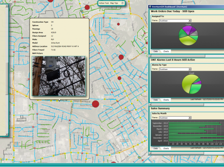
ETI’s Intelegrate platform integrates with Esri’s ArcGIS to add another layer of operational visibility. By overlaying real-time device telemetry on GIS maps, operators can see not just where assets are, but how they’re performing. That connection between spatial data and live network data gives NOC and engineering teams a more complete picture of the network without toggling between disconnected tools. Learn more about how ETI and Esri work together.
Getting Your GIS Data Right
GIS accuracy in telecom and broadband comes down to how well your spatial data flows into and through your mapping environment. When data from multiple sources arrives in different formats with mismatched coordinate systems and attribute structures, errors compound across every workflow that depends on your maps.
Data interoperability gives your team a way to connect, transform, and standardize that data before it causes problems. Aligning CAD designs with GIS records, automating recurring imports, and keeping asset data in sync with field updates all get easier when your spatial data pipeline is built to handle multiple formats and sources. The payoff is cleaner maps, better planning, and fewer costly surprises in the field.
Want to see how this fits your environment? Contact ETI to walk through your GIS and network integration needs.
Frequently Asked Questions
What is ArcGIS data interoperability?
ArcGIS data interoperability is the ability to bring spatial data from different sources and formats into a single GIS environment where it’s accurate, consistent, and usable. The ArcGIS Data Interoperability extension enables this through spatial ETL tools built on Safe Software’s FME technology.
Why does GIS accuracy matter for telecom operators?
GIS drives network planning, construction coordination, asset tracking, and service area reporting. When spatial data is inaccurate, operators deal with misaligned fiber routes, flawed availability maps, and asset records that don’t match what’s in the field.
What data formats does the ArcGIS Data Interoperability extension support?
The extension supports hundreds of spatial and non-spatial data formats, including CAD files, KMZ files, database connections, cloud warehouses, feature layers, and more. A complete list of supported formats is available through Esri’s documentation.
How does data interoperability improve GIS data quality?
It automates the process of converting, reprojecting, and standardizing data from multiple sources before it enters your GIS. This reduces manual cleanup, eliminates human error, and keeps your maps consistent as new data flows in.
Can network telemetry data be integrated with GIS?
Yes. Platforms like ETI’s Intelegrate connect real-time device telemetry with Esri’s ArcGIS, allowing operators to overlay network performance data on their GIS maps for a more complete view of both assets and how they’re performing.